行程表 (word file for the schedules of Arctic trip):
0708, 0709, 0710, 0711, 0712, 0713, 0714
0715, 0716, 0717, 0718, 0719, 0720, 0721
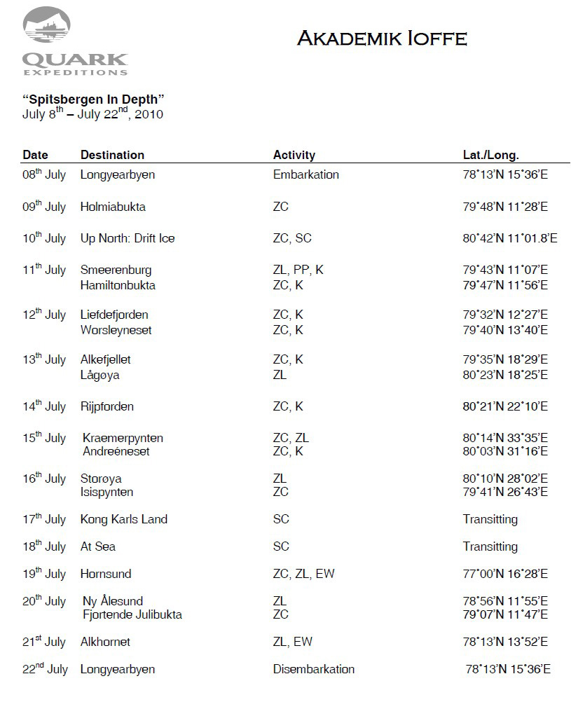
01 day (2010.7.8) Longyearbyen, Svalbard
Embarkation – All aboard!
Mandatory Lifeboat Briefing
02 day (2010.7.9) Heading North & Holmiabukta, Svalbard
a mandatory AECO & Safety briefing
a mandatory Zodiac briefing
Boot Fitting
Zodiac cruise in Holmiabukta
Holmiabukta is a small bay tucked into the northwest coastline of Spitsbergen. The landscape surrounding it is rocky, barren and, in most areas, very steep. There is a relatively large and steep glacier at the head of the bay, which is likely to still be holding fast ice. Holmiabukta, due to its small size and high surrounding peaks, feels very much like an icy amphitheatre. We hope to find Polar bears in the area, and this bay can certainly provide a unique setting to view them in.
03 day (2010.7.10) Expedition Day: Up North to the Pack Ice, Svalbard
Bear Patrol and Pack Ice
Polar Bear presentation
04 day (2010.7.11) Smeerenburg & Hamiltonbukta, Svalbard
land at Smeerenburg
The name “Smeerenburg” means “Blubber Town”. Its whaling station served as the main base for Dutch whaling in the first half of the 17th century, which was the period when whale hunting was still happening along the coastline and in the fjords of Svalbard. Smeerenburg is situated on the island of Amsterdamøya, surrounded by fjords, tall glacier fronts and steep, rugged mountains. The most obvious sign of its days as a whaling station are the large cement-like remains of blubber ovens where the blubber was boiled. The rest of the old Smeerenburg has largely disappeared under layers of sand.
No other station from the whaling periods in Svalbard has had nearly as much praise and mention as this legendary blubber town. Many myths and fabulous stories have been told of its vitality and size: In 1920, Nansen described hundreds of ships mooring in the fjord, and a lively town, abundant in riches. He spoke of a town with stands and streets, where up to ten thousand people gathered in the summer, all in connection with the whaling.
Expedition Afternoon in Hamiltonbukta
Hamiltonbukta is a westward branching arm of Raudfjorden, named after Count Hugo Vilhelm Hamilton, a Swedish naval officer (1859-1919). He was the Captain of one of the ships used during the Arc-de-meridian expedition in 1899. At the western end of the Hamiltonbukta lies the mighty Hamiltonbreen, a 5km long and 3km wide glacier. Hamiltonbukta also contains the largest bird cliff the Raudfjord area, with the Brünich’s guillemot being the most abundant breeding species.
05 day (2010.7.12) Liefdefjorden & Worsleyneset, Svalbard
zodiac cruise Liefdefjorden
Liefdefjorden is a westward branching arm of Woodfjorden, which, with the entrance being 13km wide, begins to get narrower and more mountainous the further it is ventured into. At the head of the 30km fjord lies Monacobreen, a mighty glacier named after Duke Albert I of Monaco, who led the expeditions that mapped the glacier in 1906-7. Currently the glacier share one calving front with Seligerbreen, altogether about five kilometers wide. Overall, the geology has a significant influence on the general appearance of the scenery. Liefdefjorden is a 17th Century Dutch name meaning “Love Bay”. The exact origin is unknown, however it was possibly named after a ship.
land at Worsleyneset
Worsleyneset is a point at the eastern end of Worsleyhamna in northernmost Haakon VII Land. It is named after Commander Frank Arthur Worsley, 1872-1943. Worsely was a British naval officer, born in New Zealand, and the leader of a British expedition to Spitsbergen and Franz Josef land in 1925.
06 day (2010.7.13) Alkefjellet & Lågøya, Svalbard
zodiac cruise Alkefjellet
Alkefjellet, simply meaning Auk Mountain or Mount Guillemot, is a spectacular bird cliff on the northeast of Lomfjordhalvøya, Ny Friesland. The sheer cliffs, which are over 100 metres in height, would be worth a visit even without any bird presence, however, the large breeding colony of Brünich’s guillemots is the obvious main attraction. During the summer season, several tens of thousands of breeding pairs occupy every square inch of rock ledge, causing the appearance of constant frantic activity. Exact counts of the birds have not yet been made, but estimates are in the order of 60,000 breeding pairs. We plan to zodiac cruise Alkefjellet as the terrain offers a unique and close approach to the bird cliffs, whereas at other sites bird cliffs may be several hundred metres above sea level.
land at Lågøya
The areas surrounding Lågøya are some of the least visited in Svalbard. This is mostly due to the fact that the few indications of depth on nautical charts suggest dangerous shallows surrounding the island. This means a longer than usual Zodiac ride from the ship in open waters. The reward, however, is a very individual landscape. Lågøya means “low island”, and it truly owes its name to its landscape characteristics. It is a former coastal plain, and it continues far underwater; depths only reach 15 metres when over 3 miles north of the island. Historically speaking, it has been a good location for polar bear encounters.
07 day (2010.7.15) Kræmerpynten & Andreéneset, Svalbard
land at Kræmerpynten, Kvitøya
Giles Land was glittering white from its highest summit down to the very edge of the sea. It was covered throughout with its soft mantle of snow; not a rock projected through it to break its spotless purity. The island rose in regular curves to an altitude of 600 or 700 feet, and was one continuous mass of ice and snow...With the sun shining upon it, White Island (Giles Island) must be a fascinating object.
- Alfred G. Nathorst, Geographical Journal, August 1899
The name Kvitøya means "White Island", and is justified by the view of the ice cap that covers 99% of the approximately 700 sq km island. "Officially", there are three small patches of ice-free land on Kvitøya: Andreéneset in the west, Hornodden in the southeast and Kræmerpynten in the east. We plan to land at Kræmerpynten, which is named after Waldemar Kræmer, a Norwegian trapper. Great care is needed when ashore in this area. Polar bears may be present even if you cannot see any; landings have had to be aborted and people evacuated quickly many times on Kvitøya and nearby Storøya because of Polar bears appearing uncomfortably close by.
land at Andreéneset, Kvitøya
Andreéneset is named after Salomon August Andreé and his ill-fated attempt to fly to the Geographic North Pole via hydrogen balloon in 1897. All three participants died here, with their remains being discovered 33 years later. Andrée neglected many early signs of the dangers associated with his balloon plan. Being able to steer the balloon to some extent was essential for a safe journey, and there was plenty of evidence that the drag-rope steering technique he had invented was ineffective; yet he staked the fate of the expedition on drag ropes. Worse, the polar balloon Örnen (Eagle) was delivered directly to Svalbard from its manufacturer in Paris without being tested; when measurements showed it to be leaking more than expected, Andrée refused to acknowledge the alarming implications of this. Most modern students of the expedition see Andrée's optimism, faith in the power of technology, and disregard for the forces of nature as the main factors in the series of events that led to his death and the deaths of his two companions.
08 day (2010.7.16) Storøya & Isispynten, Svalbard
Excursion at Storøya
The name Storøya means “Great Island”, which was either a mistake or a sarcastic joke due to the islands modest size of only 40 sq km and its close position to the much larger Nordaustlandet, which lies just west of it. Storøya, like Kvitøya, have been closed off throughout the whole summer by dense drift ice until the late 20th Century, however, as we know, we still need luck to be able to land and even cruise these islands by Zodiac. Drift ice can easily block the shore, the waters are not well charted and bears are an inevitable threat. Storøya has approximately 5 sq km of ice-free land at the north tip of the island. It consists of low-lying rocky elevations and is an extensive series of raised beaches. This topography provides many depressions for wildlife to be hidden, thus great care will be taken whilst landing.
Excursion at Isispynten
Isispynten is named after a river that runs through Oxford and was given by an expedition from there in 1935/36. Isispynten was once buried by the Austfonna ice cap of southeast Nordaustlandet, and until the 1990’s was a peninsula connected to the ice cap well itself. It is now a separate island, which can be circumnavigated in small boats. It has only a surface area of about 1 sq km, and its future is uncertain. It is possible, once the dead buried ice of the island has disappeared, that only sand, gravel and some boulders will be left. It is also possible that sea level rise will engulf the island, including it in the surrounding bathymetry. It is also possible that the Austfonna ice cap will advance, engulfing it once more as it had done for millennia before. The ice cliff at Austfonna is almost 200 kilometres long, making it the longest in the northern hemisphere.
09 day (2010.7.17) Kong Karls Land & Sea Ice, Svalbard
Expedition cruising at Kong Karls Land
“Some fifty-five miles east of Barendsz Land and twenty-five miles south of North-East Land is a group of rather large islands properly called Wiches Land, but now generally known as King Carl’s Land. These we had the rare good fortune to approach very closely, a thing seldom possible”.
- Martin Conway, The First Crossing Of Spitsbergen
It is the very high density of Polar bear dens that give rise to the biological importance of Kong Karls Land. The highest density of polar bear dens have been observed on Kongsøya, a 191 sq km island within the archipelago, with up to ten dens per sq km. This means that the majority of Polar bears in the northeast Atlantic region are born in Kong Karls Land. In the early 1900’s however, news about the high density of Polar bears attracted Norwegian sealers and in the 1908/1909 season, their catch was no less than 90 Polar bears. The first scientific expedition to visit the area was in1898, and was charged with finding the missing Andreé expedition.
10 day (2010.7.18) Rounding Sørkapp & Turning North, Svalbard
09:30
Those from port side cabins, please join our historian Scott for Franklin’s Fate: The Great Arctic Mystery in the Presentation Room on Deck 1
Those from starboard side cabins, please join our geologist Yvonne for Geology Rocks! in the Dining Room on Deck 3
10:45 Those from starboard side cabins, please join our historian Scott for Franklin’s Fate: The Great Arctic Mystery in the Presentation Room on Deck 1
Those from port side cabins, please join our geologist Yvonne for Geology Rocks! in the Dining Room on Deck 3
14:30 Those from port side cabins, please join Mikolaj for Strangers In Paradise: Life On An Antarctic Research Base in the Presentation Room on Deck 1
Those from starboard side cabins, please join Christian for Why We Do It in the Dining Room on Deck 3
15:45 Those from starboard side cabins, please join Mikolaj for Strangers In Paradise: Life On An Antarctic Research Base in the Presentation Room on Deck 1
Those from port side cabins, please join Christian for Why We Do It in the Dining Room on Deck 3
11 day (2010.7.19) Hornsund, Svalbard
ship cruise in Hornsund to look for bears
Almost 30 kilometres long and ten wide at the entrance, Hornsund is not only the southernmost fjord in Spitsbergen, but also, as many say, the most beautiful. It has eight calving glacier fronts and several impressive mountain peaks, including Hornsundtind, the third-highest mountain of the Svalbard archipelago at 1,431 metres. Brepollen literally means “Glacial bay” due to its heavily glaciated coastline, and is situated at the eastern terminus of Hornsund. Count Wilczek of Austria visited the area in 1872 during a support expedition and Brepollen was the only part of Hornsund in which he did not leave any placenames behind. Why was this? This was simply because Brepollen did not exist until the early 20th Century. In1900, all the glaciers surrounding the bay were combined into one giant face. Since then, the glaciers have retreated, thus forming the stunning bays that we plan to visit.
zodiac cruise in Burgerbukta
Burgerbukta is situated on the north side of Hornsund, which itself is really Spitsbergen in a nutshell, due to the conglomeration of high Arctic features it contains; there are impressive mountains and glaciers, a bird cliff, a lonely trapper’s hut and a bay that is often filled with icebergs and bergy bits.
12 day (2010.7.20) Ny Ålesund & Fjortende Julibukta, Svalbard
land at Ny Ålesund
Ny Ålesund is a former mining community established in 1917 by Kings Bay Kul Company A/S on the southern coast of Kongsfjorden, Brogerhalvoya. The name was given by the company, which had headquarters in Ålesund, Norway, though coal was initially discovered at this site by British whalers over 300 years prior. In 1925, Roald Amundsen made an unsuccessful attempt to reach the North Pole with two seaplanes, N-24 and N-25. The following year however, the Amundsen-Ellsworth-Nobile Expedition launched the airship Norge from Ny Ålesund, successfully reaching the Pole. Coal mining was closed down in 1963 after a major accident and since 1967 research activities have dominated. This is due in part to its variety of marine and terrestrial environments. In 2002 France, Germany, Italy, Japan, Norway and the United Kingdom had research stations in Ny Ålesund.
zodiac cruise Fjortende Julibukta
Fjortende Julibukta, or 14th of July Glacier as it is referred to in English, boasts magnificent scenery including a calving glacier and a cliff on the north side of the bay holding breeding seabirds. The glacier of Fjortende Julibreen calves into the sea along a three-kilometre-wide glacier front. It is a typical valley glacier with an area of approximately 81 km2 and is about 1200 metres above sea level at its highest point. At the north side of the bay of Fjortende Julibukta, a steep mountain ridge rises from sea level to a height of almost 1000 m: the Casimir-Périerkammen. Here lies a great bird cliff housing northern fulmar, kittiwake and Brünnich’s guillemot as the dominating species. Keep a watchful eye out, as Puffins are known to nest in the area aswell.
13 day (2010.7.21) Alkhornet, Svalbard
land at Alkhornet
Alkhornet is an imposing landmark at the northern entrance of Isfjorden. Although striking at 437m high, it is also one of the major bird cliffs in the Isfjorden area, housing mainly guillemots. The landscape around the cliff is lush and beautiful, fertilized by large amounts of guano and sitting upon calcareous bedrock. East of Alkhornet is a deep and several kilometre long bay with an exciting and diverse history. Here you can find important and vulnerable cultural remains dating from several of Svalbard’s historical periods. Alkhornet and Trygghamna offer visitors an interesting combination of cultural history and natural environment. The name of Trygghamna, which literally means the safe harbour, refers to the good mooring conditions and the sheltered harbour, offering lee of most winds. We hope to encounter Svalbard reindeer in the area and, with a little luck and a keen eye, some Arctic foxes.
Voyage Map
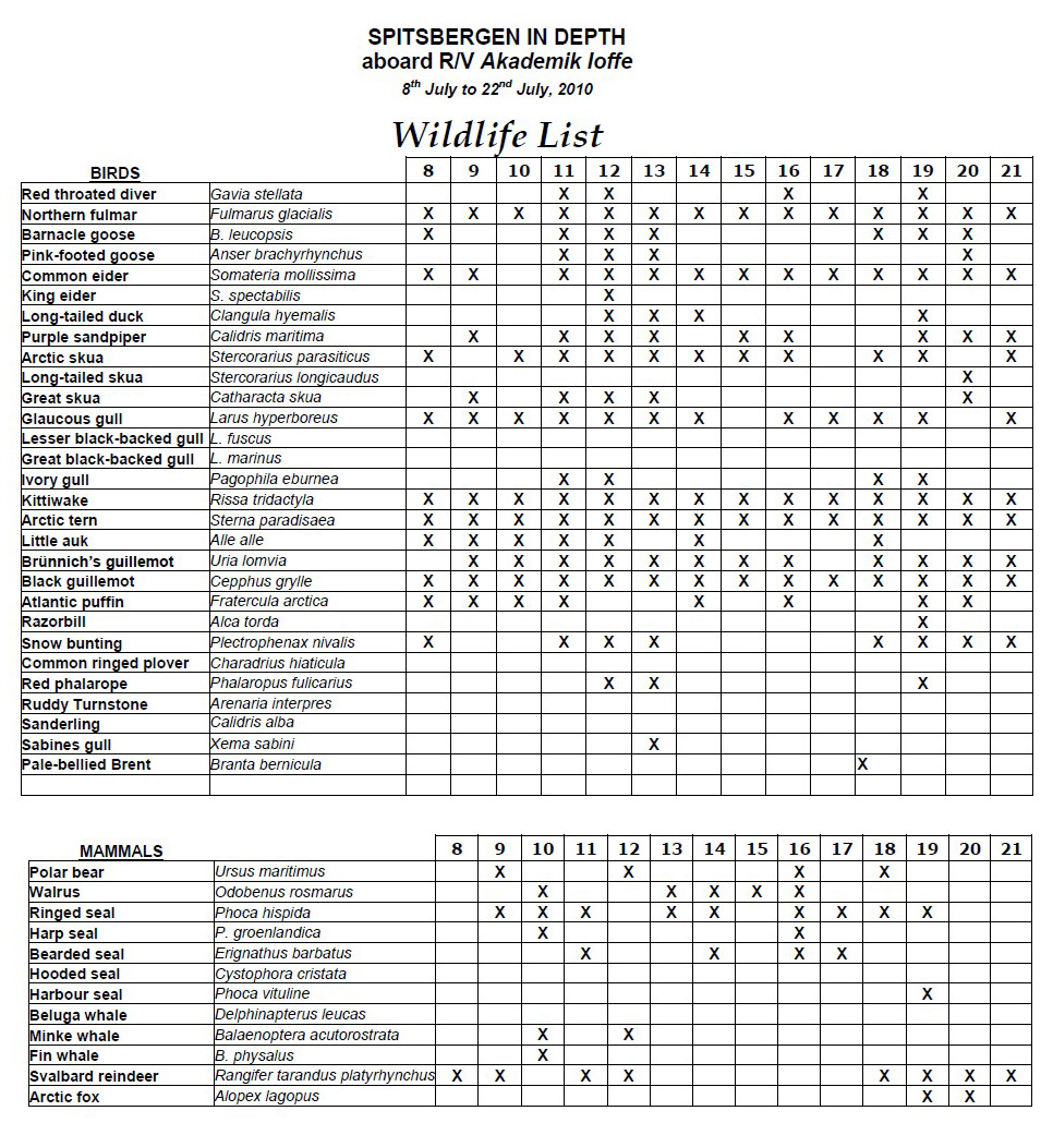
 Wildlife List
 行程緯度紀錄 Latitude
 Arctic 北極相關網站
 北極:
北極: Wildlife List
行程緯度紀錄 Latitude
Arctic 北極相關網站
Wildlife List
行程緯度紀錄 Latitude
Arctic 北極相關網站