 ж≠їдЇ°и∞ЈпЉЪ
жИСеЦЬж≠°йЫ™еЬ∞гАБдєЯеЦЬж≠°ж≤ЩжЉ†жЧ±еЬ∞пЉМйАЩжђ°еИ©зФ®йА±жЬЂеОїдЇЖгАМж≠їдЇ°и∞ЈгАНгАВдЄАиИђдЇЇдЊЖж≠їдЇ°и∞ЈпЉМйАЪеЄЄйГљжШѓиК±дЄА姩йЦЛиїКиµ∞й¶ђзЬЛиК±пЉМдЊњйЫҐйЦЛдЇЖгАВж≠їдЇ°и∞ЈжЬЙдЇЫгАМзµХе¶ЩгАНзЪДеЬ∞жЦєдЄАеЃЪи¶БйЦЛеРЙжЩЃиїКжЙНиГљйА≤еОїпЉМиАМеП™жЬЙдЊЖиґЯгАМеРЙжЩЃиїКгАНз©њиґКжЈ±е±±е≥їи∞ЈпЉМжЙНзЃЧжШѓзЬЯж≠£дЊЖйБОж≠їдЇ°и∞ЈгАВ
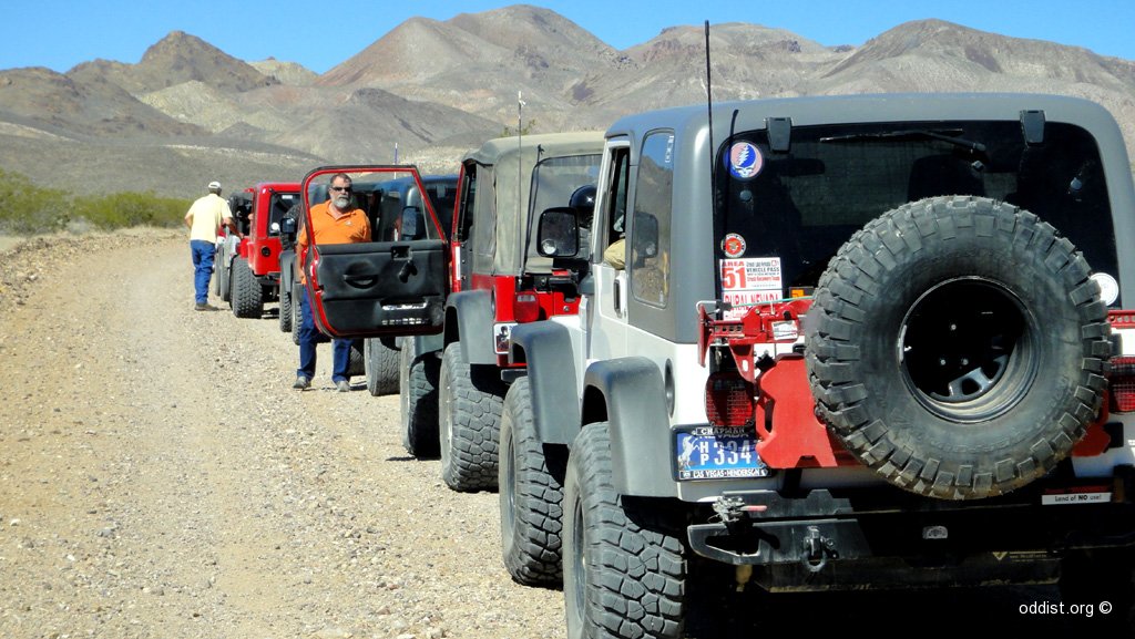
жИСеАСжШѓеЊЮжЯПеЕЛиРК(Berkeley)йЦЛдЇЖ9е∞ПжЩВдЊЖеИ∞ж≠їдЇ°и∞ЈгАВдЊЖж≠їдЇ°и∞ЈеїЇи≠∞иЗ≥е∞СиК±дЄЙ姩俕дЄКзЪДжЩВйЦУпЉМе•ље•љжККж≠їдЇ°и∞ЈжОҐз©ґдЄАзњїпЉМеЬ®ж≠їдЇ°и∞ЈзО©еЗЇзФЯеСљжіїеКЫгАВж≠їдЇ°и∞Је§ІйГ®еИЖеЬ∞йїЮйЦЛдЄАиИђиїКеН≥еПѓпЉМдљЖи¶БеОїжОҐи®™дЄАдЇЫжЈ±е±±е≥їи∞ЈеЙЗйЬАзІЯеРЙжЩЃиїКпЉМжЬЙдЇЫжЧЕ駮жЬГжПРдЊЫеЕНи≤їжИЦдЊњеЃЬзЪДеРЙжЩЃиїКеЗЇзІЯгАВ
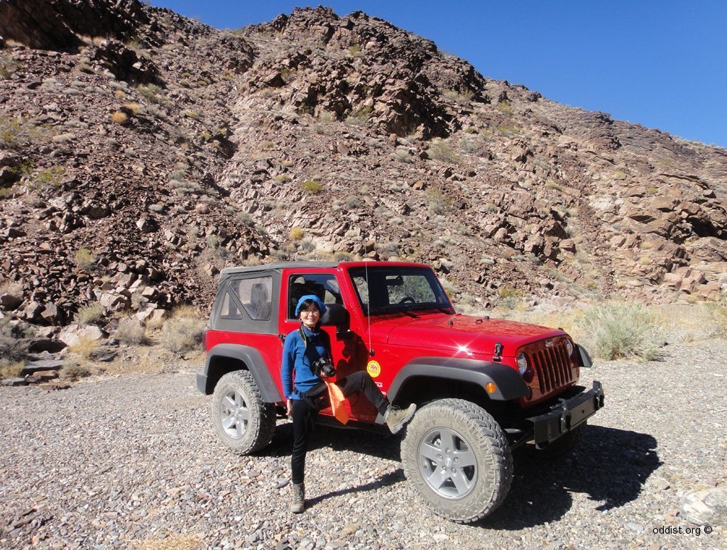
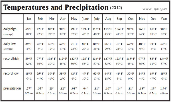
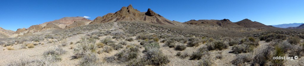
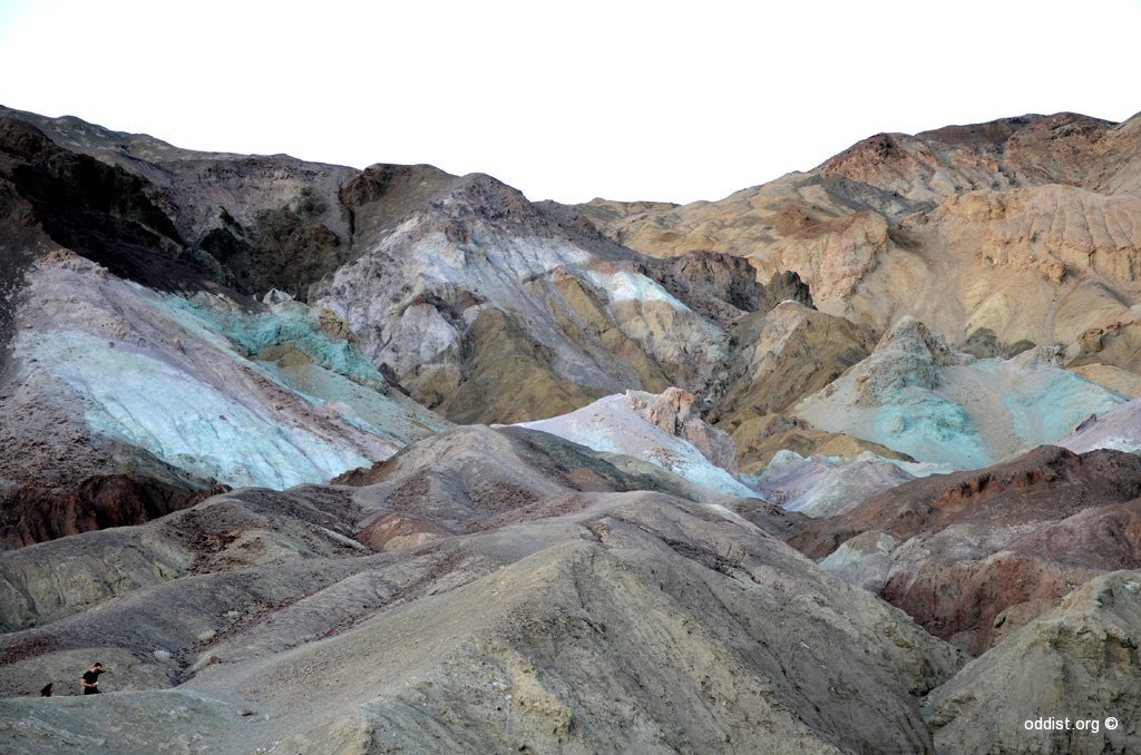
ж≠їдЇ°и∞ЈжШѓеАЛйЭЮеЄЄж•µзЂѓзЪДеЬ∞жЦєпЉМжШѓзЊОеЬЛжЬАе§ІзЪДеЬЛеЃґеЕђеЬТпЉМеМЧзЊОжµЈжЛФжЬАдљОзЪДеЬ∞жЦєеЬ®йАЩи£°пЉМжЬАйЂШжЇЂзЪДзіАйМДдєЯеЬ®йАЩи£°пЉИжЫЊжЬЙжФЭж∞П57еЇ¶пЉЙпЉМйЩНйЫ®йЗПжЬАдљОзЪДеЬ∞жЦєдєЯеЬ®йАЩи£°гАВж≠їдЇ°и∞ЈжЬЙж≤ЩжЉ†гАБжЬЙе≥љи∞ЈгАБжЬЙзБЂе±±е≤©гАБжЬЙжЬГиµ∞еЛХзЪДзЯ≥й†≠гАБжЬЙйђЉеЯОгАБжЬЙйєљи∞ЈгАБжЬЙи™њиЙ≤е±±и∞ЈвА¶..гАВйАЩз®Ѓж•µзЂѓпЉМеЊИе•љзО©пЉБ
дљЖйАЩжђ°еНїйБЗеИ∞зђСдЄНеЗЇдЊЖзЪДдЇЛ вАУ еЬ®йВ£жФЭж∞П48еЇ¶зД°дЇЇзЕЩзЪДж≤ЩжЉ†жЧ±еЬ∞иїКе≠РжЛЛйМ®гАВж≠їдЇ°и∞ЈйЭҐз©Неї£е§ІпЉМеєЊеСЉж≤ТдЇЇзЕЩпЉМеЬ®йА±жЬЂеЗЇдЇЛпЉМйВ£зЬЯжШѓеπ姩дЄНйЭИгАБеСЉеЬ∞дЄНжЗЙгАВзХґеЬ∞зХґзДґж≤ТжЬЙеЕђиїКгАБи®Из®ЛиїКпЉМйА£жЙЛж©ЯйГљжЬ™ењЕ и°МеЊЧйАЪпЉМеПЂи≠¶еѓЯдїЦеАСдєЯдЄНзРЖгАВж∞іеЄґдЄН姆пЉМжШѓеЊИеН±йЪ™зЪДгАВз≠ЙеЊЕжХСжПійБОз®ЛпЉМжЬЙйїЮзЛЉзЛљпЉМдЄНйБОйВДжШѓе•љзО©еХ¶гАВеЬ®йВ£з®ЃжЩВеАЩпЉМе∞±жШѓи¶БзЩЉжПЃгАМиЛ¶дЄ≠дљЬж®ВгАНз≤Њз•ЮпЉМиЃУиЗ™еЈ±зєЉзЇМгАМзО©иАНгАНйЦЛењГпЉМжККиЗ™еЈ±й†ЖеИ©жХСеЗЇдЊЖгАВ
еѓ¶зФ®и≥Зи®К
- Death Valley National Park, [Visitor Guide 2012 (pdfж™Ф)]
- Death Valley National Park (wikipedia)
- Death Valley MAP
- Death Valley 姩ж∞£й†Р冱
- еЕґдїЦи≥Зи®К
ж≠їдЇ°и∞ЈдЄїи¶БеРЂжЬЙеЫЫеНАпЉЪ(1)Furnace Creek Area (2)ScottyвАЩs Area (3)Stovepipe Wells Area (4)Panamint Springs Area

(дЄА) Furnace Creek Area
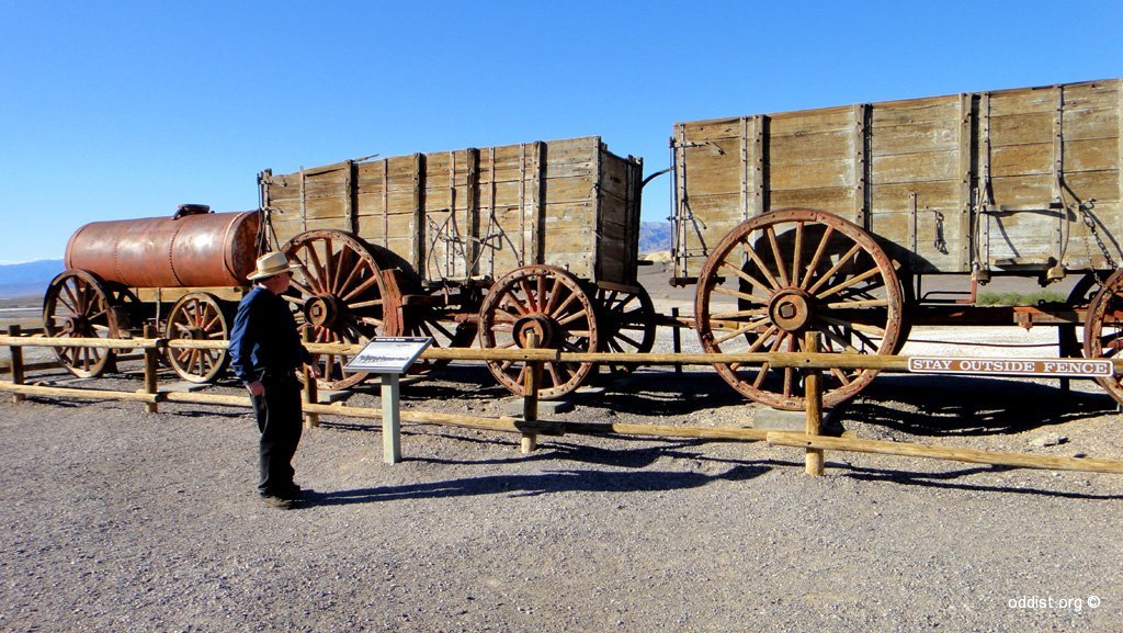
- Harmony Borax Works еТМиЂІз°Љз†ВиИКеЈ•еї†
Follow an easy 1/4 mile walking trail to learn about this important site in Death ValleyвАЩs history. The Harmony Borax operation became famous through the use of 20 mule teams that moved borax from Death Valley to nearby communities. жЬЙйБОеОїз°Љз†ВиИКеЈ•еї†зЪДйБЇиЈ°гАВеТМиЂІз°Љз†Веї†еК†еЈ•з°Љз†В秶еЊЮзИРе∞Пж≤≥йЩДињСе§ІзіД1884еєіеИ∞1888еєігАВ дЇМеНБй®ЊйЪКи≤®иїКжЛЦжЛЙпЉМ秶зЯ≥165иЛ±йЗМйБ†зЪДиїНйЬАгАВ - Artist Drive иЧЭи°УеЃґиїКйІЫйБУ гАБ Artist Paletts иЧЭи°УеЃґи™њиЙ≤зЫ§е±±и∞Ј
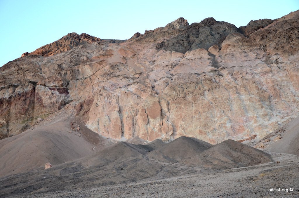
A scenic loop drive through multi-hued volcanic and sedimentary hills. ArtistвАЩs Palette is especially photogenic in late afternoon light. The 9 mile paved road is one-way and is only drivable with vehicles less than 25 feet in length. йЭЮеЄЄзЊОзЪДдЄАжҐЭиЈѓпЉМйАЩжЃµжЃµиЈѓйЬАйЦЛиїКгАВиЧЭи°УеЃґи™њиЙ≤зЫ§е±±и∞ЈжШѓеЬ®иЧЭи°УеЃґиїКйІЫйБУзЪДе∞ЊзЂѓгАВ дЄАеЃЪи¶БеОїгАВ - Badwater Basin е£Юж∞ізЫЖеЬ∞ (* hiking)
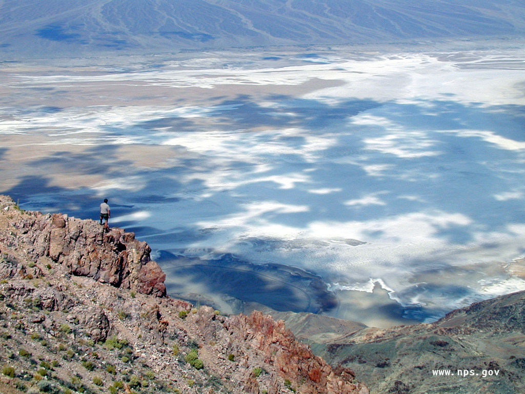
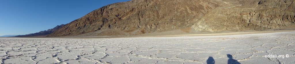
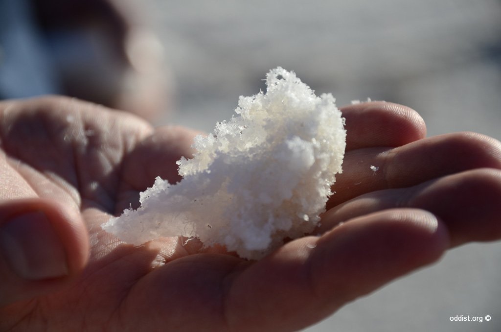
The lowest point in North America, Badwater Basin is a surreal landscape of vast salt flats. A temporary lake may form here after heavy rainstorms. Do not walk on the salt flats in hot weather. дЄАеЃЪи¶БеОїгАВ
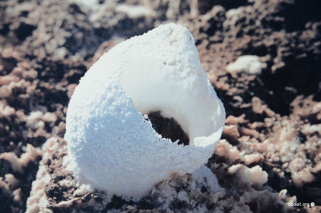
дЄАе§ІзЙЗдљОжЦЉжµЈжЛФдї•дЄЛ100иЛ±е∞ЇзЪДйєљи∞ЈеЬ∞пЉМзІСеЊРеЃґзЩЉзПЊйєљжЩґжЬЙдЇЖе≠Шжії3иРђеєідєЛдєЕзі∞иПМгАВжУЪиЛ±еЬЛгАКжЦ∞зІСе≠ЄеЃґгАЛйЫЬи™М冱е∞ОпЉМзЊОеЬЛзІСе≠ЄеЃґз†Фз©ґзЩЉзПЊпЉМеЬ®дЄАе°КйєљжЩґдЄ≠зЩЉзПЊдЇЖе≠Шжії3иРђеєідєЛдєЕзі∞иПМпЉМеЃГеАСдї•еРМж®£иЇЂйЩЈеЫєеЬДзЪДиЧїй°ЮйБЇй™ЄзВЇй£ЯгАВйАЩжШѓињДдїКжЬЙйЧЬзФЯзЙ©йЂФйХЈжЬЯзФЯе≠ШзЪДжЬАеЕЈи™™жЬНеКЫзЪДдЊЛи≠ЙгАВзЊОеЬЛе§Пе®Бе§Је§Іе≠ЄеЊЃзФЯзЙ©е≠ЄеЃґеЄГиРКжБ©-иИТдЉѓзЙє(Brian Schubert)еПКеРМдЇЛе∞НеЊЮеК†еИ©з¶Пе∞ЉдЇЮеЈЮвАЬж≠їдЇ°з©АвАЭжПРеПЦзЪДж≤Йз©Не≤©ењГдЄ≠зЪДйєљжЩґйА≤и°МдЇЖз†Фз©ґгАВйєљжЩґдЄ≠еРЂжЬЙеЊЃе∞ПзЪДжґ≤йЂФиҐЛзЛАзЙ©пЉМиИТдЉѓзЙєзЪДз†Фз©ґе∞ПзµДзЩЉзПЊпЉМ姙еП§иПМиРљиГљ дЊЭйЭ†йАЩдЇЫжґ≤йЂФзЪДж®£жЬђе≠ШжіїгАВдїЦеАС祯еЃЪдЇЖжґ≤йЂФзЪДеєідї£еЬ®иЈЭдїК2.2иРђиЗ≥3.4иРђеєіеЙНгАВ姙еП§иПМиРљеПѓдї•еАЯеК©йєљжЩґеЕІзЪДжґ≤йЂФзФЯйХЈпЉМиАМйєљжЩґзЪДж≠ЈеП≤дєЯеПѓињљжЇѓиЗ≥3.4иРђеєіеЙНгАВйАЩдЄНжШѓзІСе≠ЄеЃґй¶Цжђ°зЩЉзПЊзі∞иПМеПѓдї•йАЪйБОйєљжЩґеЕІжґ≤йЂФеМЕйА≤и°МеЯєй§КзЪДдЊЛи≠ЙгАВеЬ®ж≠§дєЛеЙНпЉМдЄАеАЛз†Фз©ґе∞ПзµДе∞±е†±еСКз®±пЉМдїЦеАСеИ©зФ®иЈЭдїК2.5еДДеєізЪДжґ≤йЂФжИРеКЯеЯєиВ≤дЇЖзі∞иПМгАВдЄНйБОпЉМзФ±жЦЉйєљжЩґжЬГйЪ®жЩВйЦУеИЖиІ£еТМеЖНзµРжЩґпЉМеЊЮиАМжНХжНЙеИ∞зПЊдї£зі∞иПМпЉМжЬЙдЇЇе∞НжЬАжЦ∞з†Фз©ґзµРжЮЬжПРеЗЇдЇЖи≥™зЦСгАВ(и≥ЗжЦЩ from зЩЊеЇ¶) - Zabriskie Point пЉИBadlands) е£ЮеЬ∞
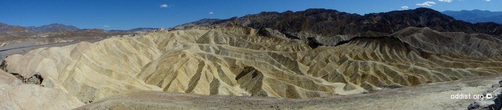
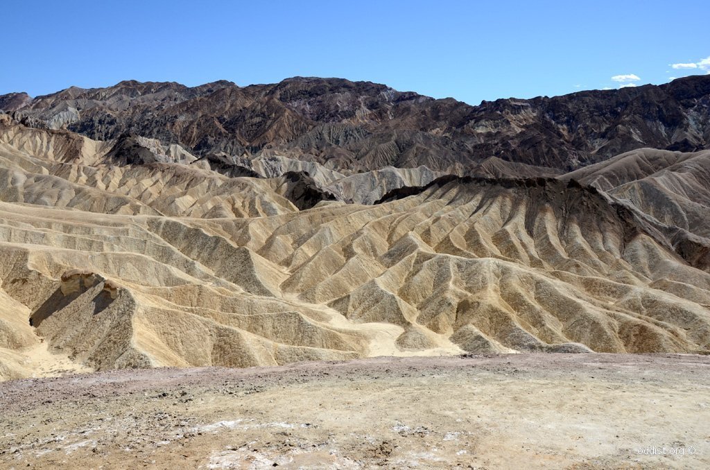
Surrounded by a maze of wildly eroded and vibrantly colored badlands, this spectacular view is one of the parkвАЩs most famous. Zabriskie Point is a popular sunrise and sunset viewing location. The viewpoint is a short walk uphill from the parking area. еЬ®йАЩжЩѓйїЮеПѓзЬЛеИ∞дЄНеРМй°ПиЙ≤жН≤жїЊзЪДе±±и∞Јж®£и≤МгАВдЄАеЃЪи¶БеОїгАВ - 20-Mule Team Canyon дЇМеНБй®ЊйЪКе≥љи∞Ј (* Jeep)
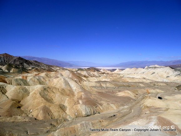
— Winding through otherworldly badlands, this 2.7 mile, oneway loop drive is unpaved, but accessible to vehicles other than buses, RVвАЩs, and trailers. йАЩжЃµжЃµиЈѓйЬАйЦЛиїКпЉИеРЙжЩЃиїКпЉЙпЉМж≤њйАФеПѓиІАи≥ЮйВ£еНГиЃКиРђеМЦиИЗеРДз®Ѓй°ПиЙ≤зЪДе±±и∞ЈпЉМзЊОж•µдЇЖгАВдЄАеЃЪи¶БеОїгАВ - Dante’s View еց冧иІАжЩѓ (* hiking)
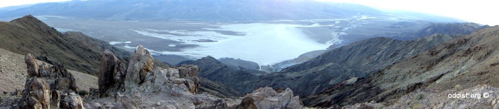
The most breathtaking viewpoint in the park, this mountain-top overlook is more than 5000 feet above the floor of Death Valley. The paved access road is open to all vehicles less than 25 feet in length. еЬ®йАЩеЕТеПѓеИ∞еИ∞жХіеАЛгАМadwater Basin е£Юж∞ізЫЖеЬ∞гАНдњѓзЮ∞пЉМеЊИзЊОгАВдЄАеЃЪи¶БеОїгАВ
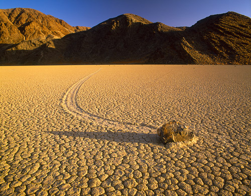
- The Racetrack жЬГиµ∞еЛХзЯ≥й†≠и∞ЈеЬ∞ (* Jeep)
Rocks mysteriously slide across the dry lakebed of the Racetrack, leaving behind long tracks for visitors to ponder. A high-clearance vehicle is needed to traverse the 27 miles of rough dirt road; ask at a ranger station for current road conditions. Once you leave pavement at Ubehebe Crater the drive will take approximately 2.5 hours one-way to the racetrack.
ж≠їдЇ°и∞ЈзЪДгАМи≥љйБУ(The Racetrack)гАНжШѓдЄАеАЛдєЊеЗЕйєљжєЦпЉМж≠§иЩХжЬАжЬЙеРНзЪДжШѓеЃГзЪДгАМжЬГиµ∞еЛХзЯ≥й†≠гАНгАВйЫЦзДґж≤ТжЬЙдЇЇзЬЯж≠£и¶ЛйБОзЪДзЯ≥й†≠зІїеЛХпЉМдљЖзХЩеЬ®ж≥•йЭҐеЊМйЭҐзЪДиЬњиЬТиїМиЈ°пЉМи≠ЙжШОдїЦеАСзЪД祯иµ∞еЛХдЇЖгАВ(дї•дЄЛи≥ЗжЦЩ from зЩЊеЇ¶)
ж≠їдЇ°и∞ЈеЬ∞йЭҐдЄКзЪДзЯ≥й†≠жЬГиЗ™еЈ≤зІїеЛХпЉМдЄ¶еЬ®еЬ∞йЭҐдЄКзХЩдЄЛеє≥и°МжїСи°МзЧХиЈ°пЉМйАЩз®Ѓе•ЗзЙєзЪДгАМжЬГиЗ™еЈ≤зІїеЛХзЪДзЯ≥й†≠йВДзХЩжЄЕжЩ∞зЪДзЧХиЈ°гАНзПЊи±°еЗЇзПЊдЇОж≠їдЇ°з©АгАМи≥љйБУзЫЖеЬ∞пЉИRacetrack PlayaгАНпЉМеЬ®ж≠їдЇ°и∞ЈжШѓе≠ШеЬ®иСЧ饮пЉМеНїдЄНиґ≥дї•е∞ЗйАЩдЇЫзЯ≥й†≠еРєеЛХгАВеЬ®зІСе≠ЄеЃґзЩЉзПЊзЯ≥й†≠зІїеЛХзПЊи±°дєЛеЙНзЪД庌姩пЉМзЫЖеЬ∞и£°жЬЙз©Нж∞іпЉМдљЖжШѓеЊИењЂзЫЖеЬ∞дєЊжЮѓзµРжИРйЊЬи£ВзЛАеЬЯ屧гАВдї§зІСе≠ЄеЃґй†ЧжЬЙиИИиґ£зЪДжШѓпЉМзЯ≥й†≠жїСи°МзХЩдЄЛзЪДзЧХиЈ°й°ѓз§ЇеЬ®ж≥•жЉњдї•дЄЛ1иЛ±еѓЄиЩХе≠ШеЬ®иСЧдЄАеАЛе†Ез°ђзЪДеЬЯе£§е±§пЉМжИСеАСиІАжЄђдЇЖж≠їдЇ°з©АињСжЬЯ庌搰饮жЪідЄ≠зХЩдЄЛзЪДеЕґдїЦж≥•жЉњжіЮпЉМдї•еПКжЄђйЗП е≤©зЯ≥жїСи°МдЄ≠йЩЈеЕ•еЬЯе£§дЄ≠зЪДжЈ±еЇ¶гАВзµРжЮЬи°®жШОйАЩдЇЫзЯ≥й†≠зФЪиЗ≥еГПжШѓеЬ®жєѓзЛАж≥•жЉњи°®е±§дЄ≠жїСи°МпЉМйЩЈеЕ•ж≥•жЉњдЄ≠дЄНиґЕйБО1иЛ±еѓЄпЉМйАЩе∞ЗиІ£йЗЛзВЇдїАйЇЉйАЩдЇЫзЯ≥й†≠жЬ™жЈ±йЩЈеЕ•ж≥•жЉњдЄ≠гАВ
еРМжЩВпЉМзІСе≠ЄеЃґдєЯжМЗеЗЇпЉМжЬ™жЬЙиЈ°и±°и°®жШОйАЩдЇЫзЯ≥й†≠зЪДзІїеЛХжШѓзФ±жЦЉйЩЈеЕ•ж≥•жЉњдЄ≠вАЬеЖ∞з≠ПвАЭйА†жИРзЪДпЉМеЬ®жХЄиЛ±йЗМзЫЖеЬ∞еНАеЯЯеЕІж≥•жЉњдєЊзЗ•жЩВзЪДиЈ°и±°й°ѓз§ЇпЉМйАЩи£°ж≥•жЉњдї•дЄЛдЄ¶дЄНеГПе≠ШеЬ®иСЧж∞іжЇРжИЦеЖ∞屧гАВиАМдЄФеЊЮзІїеЛХзХЩдЄЛзЪДзЧХиЈ°дЊЖзЬЛпЉМдЉЉдєОзЯ≥й†≠зЪДзІїеЛХжШѓеЬ®зЫЖеЬ∞дЄ≠ж≤ТжЬЙж∞іжЩВ嚥жИРзЪДгАВж≠§е§ЦйВДжЬЙдЄАеАЛе•ЗзЙєзЪДзПЊи±°жШѓзЯ≥й†≠зІїеЛХеЊМеЬЯе£§зЪДе†Жз©НиЃКеМЦпЉМзІСе≠ЄеЃґзЬЛеИ∞зЯ≥й†≠зІїеЛХзХЩдЄЛ4-5иЛ±еѓЄеѓђзЪДеЬЯ е£§е†Жз©НпЉМеЬ®зЯ≥й†≠зІїеЛХжЬАеЙНжЦєе†Жз©НиСЧ1-2иЛ±еѓЄеОЪзЪДеЬЯе£§пЉМеЊЮиАМй°ѓз§ЇзЯ≥й†≠зІїеЛХжЩВеЬЯе£§еНБеИЖйђЖжХ£гАВеБЗи®≠йАЩе¶ВжЮЬжШѓжڳ饮姩ж∞£жИЦеЕґдїЦињіеЬИ饮еКЫе∞ОиЗізЪДпЉМдљЖзВЇдїАйЇЉдЇЇеАСеЊЮжЬ™зЬЛеИ∞ е¶Вж≠§еЉЈеЛБзЪДжڳ饮зПЊи±°гАВйАЩдЇЫзЯ≥й†≠зІїеЛХзЪДзЧХиЈ°еЊИзЯ≠пЉМеЬ®еЬЯе£§дЄ≠зХЩдЄЛзЪДжїСи°МжЈ±еЇ¶дЄ¶дЄНжЈ±гАВдљЖжШѓйАЩдЇЫзІїеЛХзЧХиЈ°еЊИе∞СжЬЙи¶ПеЊЛпЉМеНїжЄЕжЩ∞ еПѓи¶ЛгАВе•ЗзЙєзЪДжШѓпЉМиÚ姆жЄЕжЩ∞еЬ∞зЬЛеИ∞4гАБ5иЩХзЯ≥й†≠зІїеЛХзЪДиїМиЈ°йГљжШѓеє≥и°МзЪДгАВе∞НжЦЉйАЩз®ЃзЯ≥й†≠зІїеЛХзПЊи±°пЉМдєЯдЄНеПѓиГљжШѓзФ±жЦЉдЇЇзВЇжХЕжДПйА†жИРзЪДпЉМе¶ВжЮЬжЯРдЇЇжХЕжДПе∞ЗйАЩдЇЫзЯ≥й†≠зІїеЛХпЉМ жЬГеЬ®зЫЖеЬ∞и°®йЭҐзХЩдЄЛиґ≥иЈ°зЪДгАВж≠§е§ЦпЉМеЬ®жЬАињСзЪДдЄАжђ°жڳ饮姩ж∞£дЄ≠жЬ™жЫЊзЩЉзПЊжЬЙзЯ≥й†≠еЗЇзПЊзІїеЛХгАВдЄАеЃЪи¶БеОїпЉМдљЖеЊИйБ†гАВ
- Ubehebe Crater (зБЂе±±е≤©)
Just a few hundred years ago a massive volcanic explosion caused by magma mixing with an underground spring, shattered the silence of northern Death Valley. When the cinders and dust settled, this 600 foot deep crater remained. Although easily visible from the paved road, hikers may want to circle the crater rim to see smaller craters. дЄАеЃЪи¶БеОїгАВ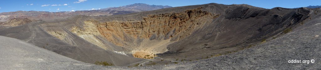
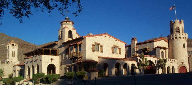
- Scotty’s Castle еП≤иАГеЄЭеЯОе†°
Prospector вАЬDeath Valley ScottyвАЭ claimed this elaborate Spanish-style mansion was built by gold from his fictitious mine. In reality, it was the 1920s vacation home of his wealthy friends. Today, living history tours of the castleвАЩs richly furnished interior are given by costumed park rangers.
йЪ±иЧПеЬ®йБ†еМЧйГ®ж≠їдЇ°и∞ЈпЉМж≠їдЇ°и∞ЈзЪДзЙІе†іпЉМжИЦжЦѓзІСиТВзЪДеЯОе†°пЉМеЫ†зВЇеЃГжШѓдњЧз®±зЪДиС°иРДе≥љи∞ЈзЪД紆жі≤пЉМжШѓеИ∞еТЖеУЃзЪД20еєідї£еТМе§ІиХ≠жҐЭ30еєідї£зЪДзФЯжіїеТМжЩВдї£зЪДз™ЧеП£гАВеЬЦзЙЗпЉЪдЊЖжЇР
- Golden Canyan йїГйЗСе≥љи∞Ј(Hiking) (* hiking)
1 mile, one-way. Golden Canyon parking area, 2 miles south of Hwy 190 on Badwater Road. Easy trail through colorful canyon. Red Cathedral located ? mile up canyon from last numbered marker. An interpretive trail guide is available. дЄАеЃЪи¶БеОїгАВ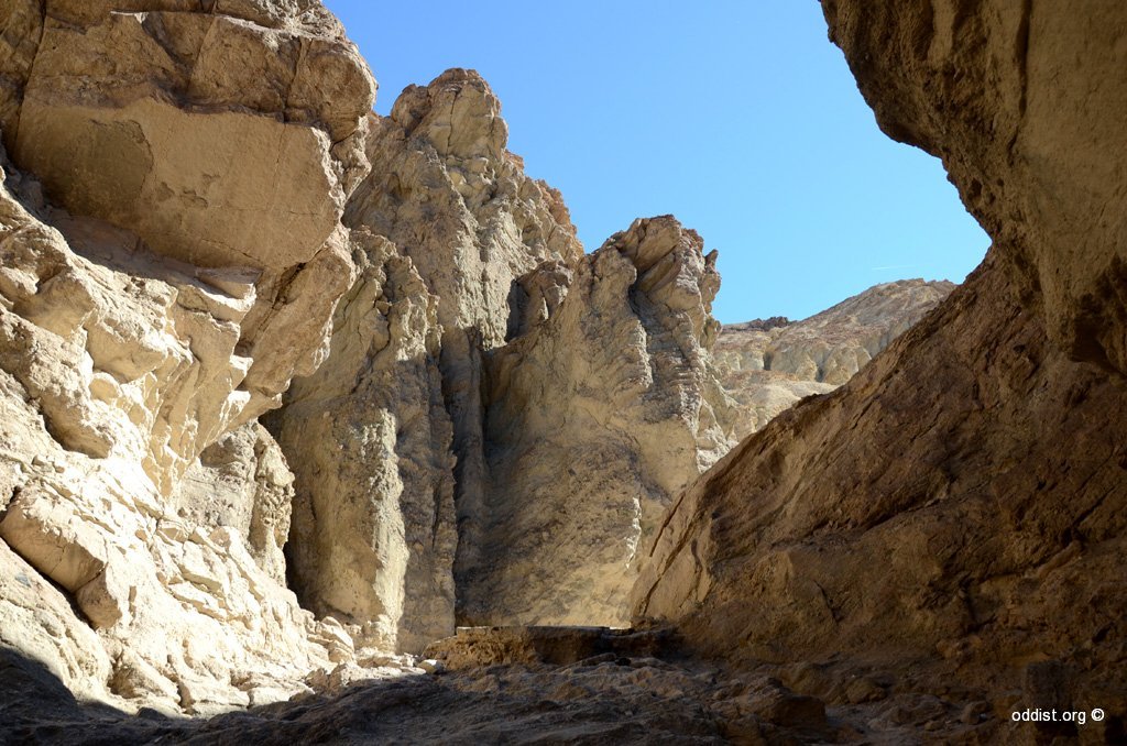
- Devil Golf Course йВ™жГ°йЂШзИЊе§Ђе†і (* Jeep)
An immense area of rock salt eroded by wind and rain into jagged spires. So incredibly serrated that вАЬonly the devil could play golf on such rough links.вАЭThe unpaved road leading to it is often closed after rain. дЄАеЃЪи¶БеОїгАВ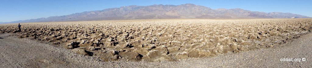
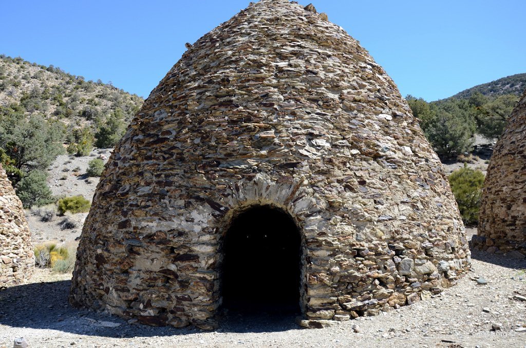
- Wildrose Charcoal Kilns Wildrose Peak Trail йЗОзОЂзС∞жЬ®зВ≠з™ѓ пЉИ* Jeep)
These ten beehive-shaped structures are among the best preserved in the west. Built in 1876 to provide fuel to process silver/lead ore, they still smell of smoke today. The last 2 miles of gravel road to the kilns are passable to most vehicles. 4.2 miles, one-way.
йАЩеНБеАЛиЬВ灱嚥зЪДзµРжІЛжШѓеЬ®и•њйГ®еЬ∞еНАжШѓдњЭе≠ШжЬАеЃМе•љзЪДжЬ®зВ≠з™ѓгАВеїЇжЦЉ1877еєіжПРдЊЫзЗГжЦЩиЩХзРЖйКА/йЙЫ秶зЯ≥гАВдЄАеЃЪи¶БеОїгАВ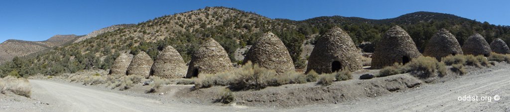
- Mesquite Flat Sand Dunes ж≤ЩдЄШ
Tawny dunes smoothly rising nearly 100 feet from Mesquite Flat. Late afternoon light accentuates the ripples and patterns while morning is a good time to view tracks of nocturnal wildlife. Moonlight on the dunes can be magical, yet night explorers should be alert for sidewinder rattlesnakes during the warm season. иЈЯйЭЮжі≤иЦ©еУИжЛЙж≤ЩжЉ†зХґзДґдЄНиГљжѓФпЉМдљЖж≤ТеОїйБОиЦ©еУИжЛЙж≤ЩжЉ†жГ≥зЬЛж≤ЩжЉ†ж≤ЩдЄШзЪДдЇЇпЉМйВДжШѓеАЉеЊЧдЄАзЬЛгАВ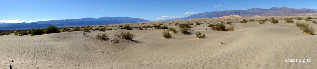
- Salt Creek йєљжЇ™ пЉИ* Jeep)
This stream of salty water is the only home to a rare pupfish, Cyprinodon salinus. Springtime is best for viewing pupfish; in summer the lower stream dries up and in winter the fish are not as active in Salt Creek. The wooden boardwalk loops 1/2 mile through stands of pickleweed and past pools reflecting badland hills. Wheelchair accessible. 1 mile off Hwy 190 on graded gravel road, 13.5 miles north of Furnace Creek. pupfish and other wildlife. Best in late winter/early spring. - Mosaic Canyon й¶ђи≥љеЕЛе≥љи∞Ј (Hiking)
Polished marble walls and odd mosaic patterns of breccia make this small canyon a favorite. The twisting lower canyon is so narrow hikers must walk through it single-file. Some rock scrambling is required. The canyon opens up after ? mile to reveal the heights of Tucki Mountain, but hikers can continue another 1 1/2miles. 2 miles, one-way. Popular walk up a narrow, polished marble-walled canyon. First ? mile is narrowest section. Some slickrock scrambling necessary. “Mosaics" of fragments of rocks cemented together can be seen in canyon walls. Bighorn sheep sighted occasionally. - Titus Canyon йАЦзЙєжЦѓе≥љи∞Ј (* Jeep)
The largest and most diverse canyon in the park. Within its lofty walls visitors can find volcanic deposits, a ghost town, Indian petroglyphs, bighorn sheep, and deep, winding narrows. Titus Canyon is accessible to high-clearance vehicles via a 26 mile, one-way dirt road beginning outside the park. The trip will take 3 hours from Beatty to ScottyвАЩs Castle Road. дЄАеЃЪи¶БеОїгАВ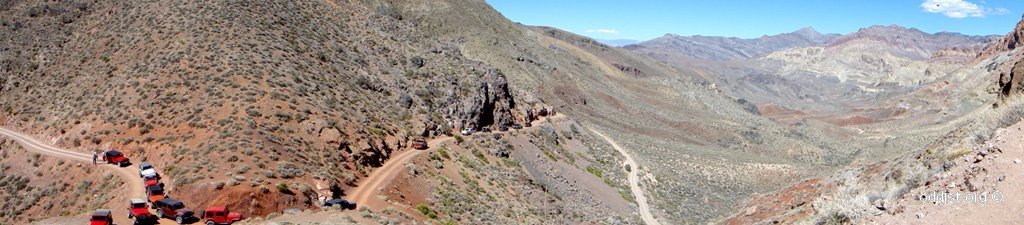
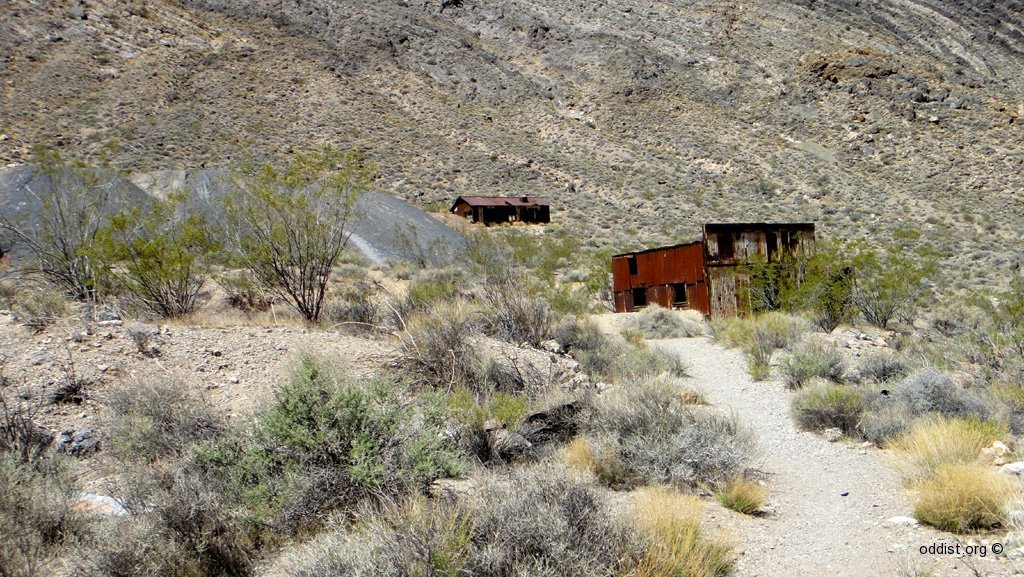
- Rhyolite (Ghost Town) зУґе≠Ре±Л
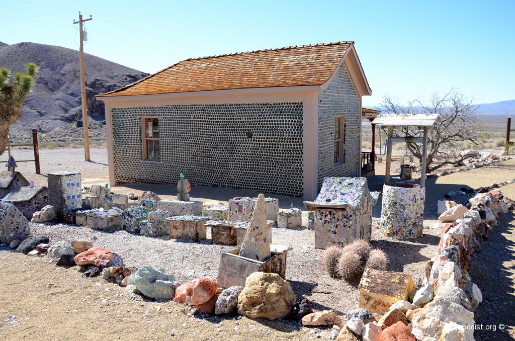
- Leadfiled (Ghost Town) йђЉеЯО
- Rainbow Canyon
- Father Crowley Vista
- Red Pass
- Fall Canyon (* Hiking)
еЬЦзЙЗпЉЪ дЊЖжЇР
(дЇМ) Scotty’s Area
 еЬЦзЙЗпЉЪ
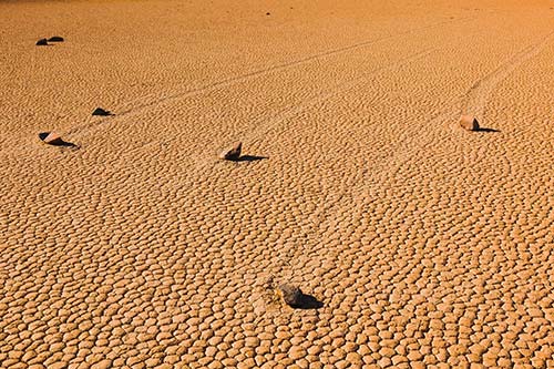
(дЄЙ) Stovepipe Wells Area
(еЫЫ) Panamint Springs Area
еЕґдїЦеПГиАГзґ≤зЂЩпЉЪ